Most Updated Satellite Map Cadence in 2026: A Practical Guide
Understand how update cadences for satellite maps vary by provider, sensor, and region in 2026. Learn to choose sources with near-real-time updates for planning, disaster response, and daily mapping tasks.

There isn't a universal 'most updated satellite map'—update cadence depends on provider, sensor type, and region. Some services offer near-real-time feeds for high-priority areas, while global coverage may lag by hours to days. For practical use, align with your region and data needs and note the refresh rates differ across platforms.
Understanding what counts as the most updated satellite map
In practice, the phrase the most updated satellite map describes feeds that deliver the latest imagery for a given area. Cadence depends on the sensor technology (optical versus radar), the provider’s constellation size, and the intended use case. Optical satellites excel in visual detail but can be hindered by cloud cover, while synthetic aperture radar (SAR) can see through clouds and operate day and night. The result is a spectrum of update frequencies, from near-real-time alerts in crisis zones to scheduled composites for broad regional monitoring. For many users, the goal is to balance freshness with spatial resolution, coverage, and cost. In 2026, the landscape includes both commercial and public-source imagery, each with different update patterns. Keep in mind that the term “most updated” is context-driven, not universal. A map may be highly current for a city block yet lag elsewhere. The practical takeaway is to match update cadence to your task—planning, emergency response, or analytics—rather than chasing a single metric of freshness.
How update cadence varies by provider and sensor type
Cadence varies widely across data sources. High-frequency feeds are common in disaster response programs or city-level monitoring, where providers re-task satellites in near-real time and publish quick-turnaround composites. For global coverage, providers often rely on larger, slower revisit cycles but compensate with frequent partial updates from multiple satellites. Radar (SAR) imagery offers reliable, all-weather updates, while optical imagery provides higher visual detail when skies are clear. Because weather, orbital scheduling, and data processing pipelines influence cadence, a single number rarely applies universally. When selecting providers, consider sensor mix, the planned geographic scope, and acceptable latency. Your use case will determine whether you prioritize near-real-time alerts or high-resolution post-processing.
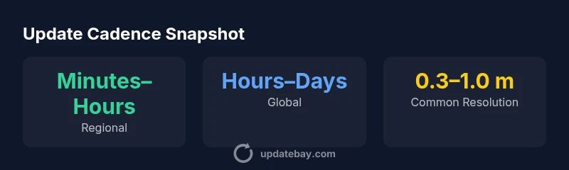
Regional versus global coverage: tradeoffs you should know
Regional maps can deliver updates on a minutes-to-hours scale because platforms focus sensors on metropolitan or crisis hotspots. Global maps are inherently slower and depend on satellite revisits and cloud-free windows for optical data, or rely on SAR for more consistent all-weather updates. The tradeoff shows up in resolution versus cadence: higher-resolution optical imagery often comes with longer delays between passes, whereas SAR can provide more frequent, though sometimes lower-detail, updates. If your work involves rapid decision-making in dynamic environments, prioritize providers offering near-real-time feeds for your regions of interest and be prepared to accept modest reductions in spatial fidelity where needed.
How to evaluate cadence: metrics and practical steps
To compare update cadences effectively, define clear metrics: (1) Refresh interval for your target area, (2) Maximum acceptable latency, (3) Spatial resolution at the update time, and (4) Availability of ancillary data (cloud masks, metadata, and sensor type). Create a short list of priority regions and test multiple sources against those criteria. Consider setting up automated checks that compare new imagery against baseline references to flag changes in a time window you care about. For crisis planning, craft a tiered approach: real-time alerts for critical zones, near-real-time updates for broader areas, and periodic high-resolution composites for long-term trend analysis. The goal is a transparent map of which source excels for which region and use case.
Real-world scenarios: when to favor fast updates vs. high detail
In urban planning, frequent updates help track growth but may require compromising on fine detail in favor of timeliness. For agriculture, timely imagery supports yield estimates and disease detection, so a mix of SAR and optical data can be ideal. In humanitarian contexts, near-real-time feeds of affected areas enable rapid response, while historical high-resolution imagery supports longer-term needs like damage assessment. Different teams may rely on different cadences, so inter-team coordination and clear data provenance are essential. Always pair the imagery with reliable ground truth or ancillary datasets to validate changes over time.
Choosing the right source for your needs: practical steps
Comparison of satellite map cadences by data source
| Source Type | Cadence | Resolution | Best Use Case |
|---|---|---|---|
| Regional Satellite Feeds | Minutes–Hours | 0.3–2.0 m | Crisis response, city planning |
| Global Optical Composites | Hours–Days | 1.0–5.0 m | Regional trend analysis, land-use mapping |
| Synthetic Aperture Radar (SAR) | Hours | 2–10 m (typical) | All-weather monitoring, coastal change |
Frequently Asked Questions
What defines the 'most updated satellite map' for a given project?
The best option depends on your use case: high-frequency updates for change detection or crisis response, versus high-resolution imagery for detailed analysis. Look for a source that aligns cadence, resolution, and latency with your needs.
The most updated map is the one that fits your task—fast enough for your decisions, with the right detail for your analysis.
Which providers offer near-real-time imagery?
Several commercial and government programs offer near-real-time feeds for specific regions or events. Availability varies by region, sensor type, and licensing. Always confirm cadence, data latency, and access terms before relying on a source for time-critical decisions.
Some providers offer near-real-time imagery for selected areas; check cadence and licensing first.
How does weather affect update cadences?
Optical imagery is highly weather-dependent and can be blocked by clouds, reducing effective update frequency. SAR imagery, which penetrates clouds, provides more consistent updates but may trade off some visual detail.
Clouds can slow optical updates, but radar data keeps coming regardless of weather.
Do cadences differ by region?
Yes. Priority regions or urban areas often receive faster updates due to demand and sensor targeting, while remote regions may see longer intervals.Y
Cities get updates faster; remote areas may lag.
What should I consider for planning and decision-making?
Define decision timelines, required resolution, and acceptable latency. Pair imagery with ground truth and metadata, and test across multiple sources to build a robust monitoring workflow.
Know your timelines and accuracy needs, then pick sources that meet those needs.
“In practice, the 'most updated satellite map' is a moving target; success comes from matching cadence, resolution, and latency to your use case.”
What to Remember
- Define your use case before choosing data sources
- Prefer SAR for all-weather frequent updates
- Expect regional feeds to be faster than global composites
- Balance cadence with requested resolution and latency
- Test sources against your priority regions before committing