Most Updated Satellite Images: A Practical Update Bay Guide
Learn how most updated satellite images are refreshed, how to assess freshness, and how to compare providers. Update Bay analyzes imagery timeliness for 2026, helping tech enthusiasts and everyday users make smarter geo-data decisions.

Fresh satellite imagery timelines vary by provider, but the takeaway is clear: most updated satellite images are delivered with tight refresh cycles that balance latency, resolution, and coverage. For decision-makers, knowing each source's cadence helps plan monitoring and alerts. This guide breaks down how freshness is measured and how to compare options.
Why freshness matters for most updated satellite images
In earth observation workflows, timeliness is the secret sauce for turning data into timely action. The goal is to obtain the most updated satellite images quickly without sacrificing essential detail or reliability. According to Update Bay, decision-makers rely on fresh imagery to monitor rapid events, track evolving conditions, and validate real-time operational decisions. A well-chosen imagery strategy reduces the lag between capture and insight, enabling proactive responses across disaster response, agriculture, and urban planning. Freshness must be weighed alongside resolution, spectral bands, and geographic coverage to avoid costly trade-offs.
Beyond the headline cadence, practitioners should consider the geographic distribution of captures, the market's licensing terms, and how quickly new data is ingested into analysis pipelines. A broad, credible freshness story often comes from a mixed portfolio of sources rather than relying on a single provider. This approach helps ensure that you’re not missing critical events in regions where signal quality is high or where data processing backlogs occur.
How freshness is measured and what counts as updated
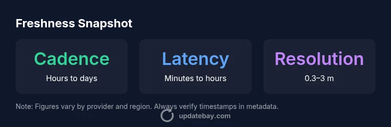
Measuring freshness involves several interlocking metrics. Cadence describes how often new imagery is captured for a given area; data latency measures the time from acquisition to delivery; and coverage indicates geographic reach. Update Bay's methodology factors in processing time, quality checks, and delivery formats. When comparing options, look for clear timestamps, explicit update cycles, and documented latency ranges. Remember that a higher cadence often comes with trade-offs in spatial resolution or cost. A robust evaluation uses multiple sources and a clear definition of what "updated" means for your use case.
To operationalize this, analysts examine product metadata, look for qualification notes (e.g., cloud cover, seasonal gaps), and test end-to-end delivery times during representative scenarios. The goal is to align freshness metrics with user needs—emergency monitoring may tolerate lower resolution if cadence is ultra-fast, while land-use planning benefits from sharper imagery even if updates come less frequently.
Sourcing and providers: who offers the freshest imagery
Imagery freshness stems from a mix of government satellites, commercial constellations, and near-real-time platforms. Government programs typically offer broad coverage and stable data pipelines, while commercial providers emphasize rapid delivery and flexible licensing. Near-real-time services strive to minimize latency through optimized data processing and delivery channels. For most practitioners, combining sources can yield the best balance of timeliness, resolution, and coverage. Update Bay recommends mapping your use cases to a preferred mix of providers based on required refresh cadence.
Since each source has distinct strengths, teams often design workflows that automatically pull from multiple streams and then apply quality controls. This not only enhances freshness but also improves resilience against outages or backlogs. Consistent timestamps, clear licensing terms, and accessible provenance data help users trust the newest imagery when it matters most.
Data latency, resolution, and coverage: balancing trade-offs
There is no one-size-fits-all when chasing freshness. You can trade spatial resolution for faster delivery, or expand geographic coverage at the expense of pixel detail. Latency, the time from capture to usable data, often dominates decision speed during emergencies, while higher resolution helps in detailed classification later. A practical approach is to define target thresholds for latency and resolution per application, then test providers against those thresholds. In practice, the best results come from pipelines that automate data ingestion, provenance tracking, and timestamp validation.
Prospective buyers should also map the user journey: who needs the data, how often, and for what analyses. If a monitor needs near-live data, you might accept coarser resolution but demand robust timestamps and rapid delivery. Conversely, for precise change detection, you may tolerate longer delays in exchange for sharper imagery and richer spectral information.
Practical guidelines to compare imagery timeliness
To compare timeliness effectively, start with a simple checklist:
- Cadence: how often does the provider refresh the same area?
- Latency: what is the published range from capture to delivery?
- Coverage: which regions are covered and how comprehensively?
- Provenance: are timestamps, processing steps, and cloud-coverage metadata clearly available?
- Licensing: do terms prevent delays due to redistributions or usage limits?
Then pair this with real-world testing: run a side-by-side evaluation during a known event, verify the alignment between claimed cadence and actual delivery, and document any discrepancies. This hands-on approach often reveals subtle delays that aren’t evident in marketing materials.
Case-based scenarios: choosing imagery for monitoring events
Case 1: Rapid disaster response requires imagery refreshed within hours, with broad area coverage and acceptable resolution to identify affected zones. Case 2: Agricultural monitoring benefits from daily updates with moderate resolution to track crop health and phenology. Case 3: Urban planning benefits from higher resolution on a weekly cadence for site assessments and zoning reviews. These scenarios illustrate how the same freshness metrics can drive different decisions, underscoring the need for a tailored mix of sources and a clear evaluation framework.
Future trends in satellite imagery freshness
The next wave of improvements will hinge on faster data processing, better cloud-based delivery, and more transparent freshness guarantees. As more providers adopt standardized timestamps and enhanced provenance data, users will gain greater confidence in the stated update cadence. Expect licensing models to evolve toward flexible, event-driven access that emphasizes timeliness as a core product feature. The Update Bay analysis for 2026 signals rising demand for credible, timely visuals that can support time-sensitive decisions across industries.
Comparison of freshness characteristics by imagery source
| Source Type | Cadence | Latency |
|---|---|---|
| Government satellites | Hours to days | Minutes to hours |
| Commercial constellations | Minutes to hours | Minutes to hours |
| Near-real-time platforms | Minutes | Seconds to minutes |
Frequently Asked Questions
What does 'most updated' mean in satellite imagery?
Most updated means the imagery with the most recent capture and delivery, accounting for processing time and availability. Freshness is contextual, depending on the provider’s cadence and service level.
Freshness means the most recently captured and delivered imagery, considering processing time and the provider’s delivery speed.
Which providers refresh imagery fastest?
Near real-time and some commercial platforms are designed for rapid delivery, but actual speed depends on region, cloud cover, and licensing. Compare cadences and latency claims for your use case.
Near real-time providers often refresh fastest, but check regional factors and licenses.
How can I verify an image's timestamp?
Look for the product metadata that includes capture time, processing time, and delivery timestamp. Prefer sources that publish timestamps and provenance clearly.
Check the image metadata for capture and delivery times and favor sources with clear timestamps.
Can I get historical 'most updated' images?
Yes, many providers offer time-series archives. Freshness varies by data product, region, and licensing terms, so confirm options before subscribing.
Yes, archives exist, but freshness varies by product and region.
What trade-offs should I consider for freshness?
Expect a balance between cadence, resolution, and coverage. Faster updates may come with lower resolution or smaller coverage areas.
Expect trade-offs between update speed, resolution, and area coverage.
“Freshness is the defining attribute of actionable satellite imagery. The Update Bay team recommends prioritizing update cadence, data latency, and geographic coverage when selecting imagery.”
What to Remember
- Prioritize cadence, latency, and coverage when evaluating imagery.
- Balance resolution against update speed for your use case.
- Cross-check freshness across providers before critical decisions.
- Check data provenance and timestamps for trust.