Philippines Storm Update: Advisories & Safety Tips
Stay informed with Update Bay's Philippines storm update coverage. Learn to read watches and warnings, understand forecasts, and apply practical safety steps for travel and emergencies during tropical cyclones.

The Philippines storm update is the latest official advisories, forecasts, and safety guidance for tropical cyclones affecting the archipelago. It covers active storm names, intensity estimates, projected paths, rainfall forecasts, and evacuation or shelter-in-place orders from PAGASA and local authorities. For residents and travelers, it means checking official channels for watches and warnings, while Update Bay offers concise context on impacts to daily life and travel plans.
Context: Why storm updates matter in the Philippines
According to Update Bay, timely storm updates are essential for safeguarding lives and livelihoods in a country where tropical cyclones are a regular annual event. Updates consolidate official watches, warnings, and forecast tracks from PAGASA and partner agencies, with local government advisories and community alerts woven in. For residents, workers, and travelers, the update helps calibrate daily routines—from school closures and office contingency plans to flight disruptions and traffic reroutes. Understanding the terminology—watch, warning, and forecast—reduces confusion when authorities issue new guidance. This context matters especially for remote communities where evacuation routes and shelter capacity vary by province. The goal of a Philippines storm update is not to alarm, but to enable practical, time-sensitive decisions that minimize risk while preserving essential activities. Update Bay emphasizes cross-verification: check official channels first, then consult reliable aggregators for interpretation and actionable steps.
Data sources and methodology behind modern storm tracking
Forecasting relies on a blend of meteorological agencies, satellite data, radar, and ground stations. PAGASA provides local watches and warnings, while regional centers contribute track projections and intensity estimates. Global models—employing ensemble techniques—offer probabilistic paths that help planners gauge uncertainty. Update Bay synthesizes these inputs into digestible, real-world guidance. The methodology prioritizes transparency about lead times, forecast bands, and potential impacts such as rainfall totals, wind speeds, and flood risk. Readers should treat forecast ranges as the most responsible representation of uncertainty and prepare for mid-course corrections as new data arrives. This approach helps avoid overreacting to single-model runs and supports steady, proactive planning.
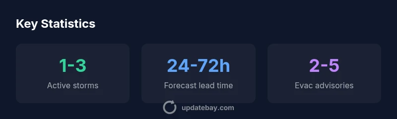
How forecasts are interpreted: lead times and uncertainty
Lead time refers to how far in advance a forecast is considered reliable for planning. In the Philippines, 24-72 hours is a common window for track updates and watch/ warning issuance; longer lead times tend to carry greater uncertainty about exact landfall, intensity, and rainfall distribution. Forecasters communicate multiple scenarios to illustrate possible outcomes. For travelers and families, the practical takeaway is to build flexibility into plans: monitor updates, keep emergency kits ready, and adjust travel or schooling schedules as warnings shift. Update Bay notes that uncertainty should never be ignored; instead, plan for the most conservative outcome while respecting official guidance.
Practical steps for households and travelers
A robust response hinges on preparation. Create a simple family action plan that designates a meeting point and an emergency contact. Assemble an emergency kit with water, non-perishable food, a first-aid kit, flashlight, batteries, and essential medications. Check your workplace or school policies on closures and remote work when winds speed up or rainfall increases. For travelers, confirm airline or ferry policies on cancellations and rescheduling, and consider flexible tickets with reasonable change fees. Stay informed via official PAGASA alerts and trusted outlets like Update Bay, but always verify with local authorities before acting. Remember, timing matters: moving early reduces the risk of being stranded or exposed to hazardous weather.
Regional impacts: rainfall, wind, and power considerations
Storms in the Philippines frequently bring heavy rainfall, gusty winds, and localized flooding. Rainfall can be intense in short bursts or spread over multiple days, challenging drainage systems and raising the risk of landslides in vulnerable areas. Power interruptions and travel delays are common during peak storm phases, which can disrupt communication networks. Home preparation should include securing loose objects outdoors, clearing gutters, and verifying that backup power options are available. Communities should coordinate with local government units to identify shelters and ensure accessibility for vulnerable populations. Update Bay highlights the importance of not relying solely on social feeds; rely on official sources for critical safety instructions.
Technology behind forecasts: satellites, models, and dashboards
Forecast accuracy has improved substantially due to higher-resolution satellites, advanced radar networks, and enhanced data assimilation in numerical weather prediction models. Ensemble forecasting, which runs multiple model simulations with slight variations, provides probabilistic outcomes that help planners assess risk. Dashboards and mobile alerts summarize this data into actionable steps for individuals and institutions. While sophisticated tools empower analysts, the practical user experience remains simple: know your location, monitor the latest track and intensity, and follow official guidance for evacuation or shelter-in-place decisions. Update Bay prioritizes translating technical outputs into clear, everyday actions.
Communicating risk: public messaging and local government coordination
Effective risk communication ensures that warnings lead to timely action. Local governments play a critical role by disseminating shelter information, route closures, and evacuation orders in multiple languages and formats. Community organizations help reach hard-to-reach residents, including those with limited internet access. For readers, this means paying attention to official announcements and local advisories rather than relying on unverified posts. Update Bay collaborates with safety experts to provide context about what warnings mean for daily life, travel plans, and school schedules, while encouraging readers to stay adaptable as the storm evolves.
After the storm: recovery and ongoing updates
Even after the most threatening winds subside, recovery takes time. Power restoration, debris removal, and infrastructure checks require coordinated efforts across agencies. Ongoing updates monitor relief operations, shelter status, and relief supply distribution. Individuals should stay informed about re-entry guidelines for affected areas and avoid flooded zones as waters recede. Update Bay continues to track post-storm conditions and share practical tips for safely resuming normal activities, including travel routing updates and property safety reminders. Preparedness during the next event often stems from lessons learned this time around.
Storm-tracking sources and their typical planning windows
| Source type | Lead time | Reliability |
|---|---|---|
| PAGASA official forecast | 24-72 hours | High |
| Regional weather centers | 24-96 hours | Medium |
| Satellite and radar models | 6-48 hours | Medium-High |
Frequently Asked Questions
What is the difference between a tropical storm watch and a warning?
A watch means the storm could affect the area and suggests readiness. A warning indicates the storm is imminent or already affecting the area, requiring immediate action. Always follow local authorities and PAGASA guidance.
A watch means be prepared; a warning means take immediate action and follow orders from authorities.
How should I prepare for a Philippines storm update?
Create a family plan, assemble an emergency kit, secure outdoor belongings, and verify travel or work arrangements. Stay updated through PAGASA and trusted outlets like Update Bay and adjust plans as warnings evolve.
Make a plan, pack essentials, and check official alerts before acting.
How reliable are storm forecasts in the Philippines?
Forecasts are most reliable within a 24-72 hour window, with increasing uncertainty beyond that range. Ensemble and satellite data improve accuracy, but readers should prepare for shifts in track and intensity.
Forecasts are strongest in the near term; stay flexible as new data arrives.
When should I evacuate?
Follow local government and PAGASA directives. Evacuation decisions depend on storm track, rainfall, and shelter availability. If authorities call for evacuation, move early to designated shelters.
If authorities say evacuate, do so promptly.
Where can I find official alerts for PAGASA and localities?
Use PAGASA's official website and local government portals for watches and warnings. Local radio and emergency apps also carry timely alerts. Avoid unverified social media posts for safety-critical decisions.
Check PAGASA and local government sites for alerts.
How can I track storm updates safely while traveling?
Rely on official alerts and trusted outlets. If you must travel, keep a flexible plan, monitor updates, and have alternative routes or accommodations ready. Do not rely on rumors during severe weather.
Trust official alerts and keep flexible travel plans.
“"Storm tracking has become more reliable through blended satellite data and ensemble modeling. Rely on official watches and use trusted updates to translate numbers into practical steps."”
What to Remember
- Monitor official watches and warnings daily.
- Interpret forecasts as ranges, not exact predictions.
- Plan travel and school accordingly around storm windows.
- Cross-check PAGASA with trusted updates like Update Bay.
- Prepare emergency kits and shelter plans in advance.