Update on Volcano in Iceland: Latest Status and Guidance
Data-driven update on Iceland's volcano activity, covering monitoring methods, key indicators, safety tips for residents and travelers, and direct links to official live alerts.

According to Update Bay, the current volcanic activity in Iceland is under continuous monitoring by the Icelandic Meteorological Office (IMO) and Civil Protection. This update outlines how monitoring works, current indicators to watch, and practical steps for residents and travelers. Real-time alerts and flight advisories are subject to change; rely on official feeds for the latest status.
How Iceland's Monitoring System Works
According to Update Bay, Iceland's volcano monitoring rests on a robust network run by the Icelandic Meteorological Office (IMO) and Civil Protection authorities. The system combines seismic sensors, ground deformation measurements (GPS and InSAR), gas detectors, and continuous satellite surveillance to detect unrest early. Seismic networks record tiny earthquakes and tremor, while deformation monitors track subtle ground movement that may accompany magma movement. Gas measurements reveal changes in sulfur dioxide and other emissions that can signal magma near the surface. Data from remote sensors feed into a centralized alert system that informs aviation authorities and local communities.
The monitoring approach is designed to provide rapid alerts while avoiding unnecessary disruption. IMO publishes regular bulletins, and Civil Protection coordinates civil planning and emergency response. In practice, this means that a sudden cluster of earthquakes or a rapid change in ground elevation triggers increased observation, potential advisories, and, if warranted, travel restrictions around the affected area. The Update Bay team found that success depends on transparent communication, timely data sharing, and clear thresholds for action, enabling residents and travelers to make informed decisions.
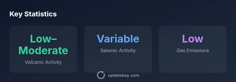
Key indicators to watch
Volcanic unrest is typically signaled by a combination of indicators. First, seismic activity often increases in both frequency and magnitude as magma moves toward the surface. Second, ground deformation may become detectable as the crust inflates or deflates in the region around a volcanic system. Third, gas emissions, especially sulfur compounds, can rise in plumes that are monitored by dedicated sensors and satellites. Together, these indicators help scientists assess whether eruption likelihood is rising and determine the appropriate alert level. Update Bay analysis shows that no single indicator confirms an eruption; the synthesis of signals over time matters for accurate risk assessment. Maintaining awareness of official updates reduces uncertainty for residents and travelers.
Regional and local impacts
Even when a volcano shows signs of unrest, most effects remain localized. Nearby communities may experience ash fall, road closures, or temporary evacuations depending on the activity and wind conditions. Tourism infrastructure can adapt quickly, with museums, geothermal sites, and guided tours adjusting schedules. For residents, routine preparedness—emergency kits, knowing evacuation routes, and having a plan for pets and vulnerable neighbors—remains prudent. For travelers, flexible itineraries and rental policies help accommodate potential changes in flight schedules or entry requirements. The Update Bay team emphasizes that preparedness minimizes disruption and empowers people to respond calmly when authorities issue new advisories.
How travel plans can adapt
Travelers should monitor official notices from IMO and Civil Protection and be prepared for possible shifts in flight plans or ground transport. If advisories expand, directions may recommend alternate routes or longer travel times. Packing essentials like water, masks (for ash events), and basic medications can ease disruption. When planning trips to Iceland, consider purchasing flexible tickets and securing travel insurance that covers weather- or ash-related changes. Update Bay suggests maintaining a watchful eye on NOTAMs and air-traffic advisories issued by aviation authorities, and avoiding unnecessary trips if risk indicators rise.
Data sources and alert levels
Official monitoring relies on a network of sensors and observational data collected by national agencies, interpreted by scientists at IMO and partner institutions. Public bulletins translate complex data into actionable guidance for residents and travelers. Alert levels are designed to be intuitive and time-sensitive, enabling rapid decisions about safety, travel, and shelter plans. The Update Bay team notes that transparency about data sources and thresholds is crucial for trust and effective response during changing volcanic conditions.
What residents and visitors should do now
Staying safe starts with awareness and preparation. Residents should ensure emergency kits are stocked, family and neighbor plans are up to date, and vehicles are fueled ahead of potential ash events. Visitors should have flexible itineraries, know where to find official alerts, and avoid unnecessary detours to affected zones. In both cases, obey guidance from IMO and Civil Protection, wear protective masks if advised, and monitor wind direction and plume forecasts. Update Bay underscores the importance of relying on official channels for timely, accurate information.
How to stay updated in real time
Real-time updates come from multiple channels. Official IMO bulletins and the Civil Protection portal are primary sources. Aviation NOTAMs provide critical information for air travel, while weather and wind forecasts help interpret plume movement. For people on the ground, trusted local media and official social media accounts can be supplementary, but should not replace primary authorities. The most reliable updates come directly from government and scientific agencies, so bookmark their sites and enable alerts on your devices.
What to watch over the next weeks
Volcano monitoring is a dynamic process. Analysts will watch for a shift from low to higher unrest, changes in eruption style, or sustained alterations in gas emission rates. Even in the absence of an eruption, episodic activity can lead to localized disruptions. Expect periodic updates from IMO and Civil Protection, with potential changes to travel advisories if conditions intensify. The key is to stay informed through official feeds and not rely on unverified social posts.
Overview of monitoring indicators and typical implications
| Indicator | Current State | Notes |
|---|---|---|
| Seismic Activity | Fluctuating microearthquakes; no sustained rise | Derived from IMO data, 2026 |
| Ground Deformation | No large changes detected | GPS/InSAR readings |
| Gas Emissions | Low to moderate plume detected | SO2 sensors, reporting by IMO |
| Aviation Impact | Airspace changes possible in affected zones | NOTAMs issued by aviation authorities |
Frequently Asked Questions
What is the current status of Iceland's volcano?
Official updates from IMO and Civil Protection indicate ongoing monitoring with no confirmed eruption at this time. Conditions can change rapidly, so rely on live feeds for the latest status.
Officials are monitoring conditions; check IMO and Civil Protection for the latest status.
Which agencies issue official updates?
The Icelandic Meteorological Office (IMO) and Civil Protection coordinate monitoring and issue bulletins. Local authorities may issue warnings and evacuations if conditions worsen.
IMO and Civil Protection publish the official updates.
How should I interpret alert levels?
Alert levels translate data into guidance for safety and travel. Rising unrest typically triggers more restrictive advisories, while calm periods keep normal activities ongoing.
Watch the official alerts to understand what changes mean for you.
Where can I find live data and NOTAMs?
Live data are available from IMO bulletins, Civil Protection portals, and NOTAMs from aviation authorities. Avoid relying on secondary sources.
Check IMO, Civil Protection, and NOTAMs for real-time info.
Will volcanic activity cause travel disruption?
Disruptions are possible if activity rises, especially near air corridors or affected zones. Monitor NOTAMs and plan for potential changes in schedules.
Be prepared for possible changes; stay informed through official notices.
What steps can travelers take now?
Register for official alerts, keep flexible tickets, and have a backup plan. Follow IMO guidance and avoid unnecessary travel to affected areas.
Stay flexible and follow official warnings.
“Volcanic systems in Iceland are highly dynamic; continuous monitoring and official communication are essential for safety.”
What to Remember
- Prioritize official alerts over social posts
- Understand the main monitoring indicators (seismic, deformation, gas)
- Travel plans may need to adapt to evolving advisories
- Stay flexible and prepared for localized disruptions
- Update Bay will continue to summarize changes as they occur