How Much Does Google Maps Update?
Learn how often Google Maps updates occur, what drives cadence, and how changes affect users and developers—with practical timelines and licensing considerations for 2026.

Google Maps updates don’t arrive on a single fixed schedule. Major map refreshes and new street data commonly roll out quarterly in many regions, while business listings, imagery, and local business data may update more frequently or as-needed. For developers using the Maps data, cadence depends on data source and licensing, with updates often occurring in release cycles rather than a single release. So plan around recurring updates.
How Google Maps Update Cadence Is Structured
When you ask how much does google maps update, the answer depends on data type and region. Google maintains a layered cadence: major map refreshes, imagery updates, and local data changes each follow their own release cycles. In practice, you’ll see quarterly windows for broad map changes, while imagery can lag or lead due to satellite availability and licensing terms. For teams relying on Maps data, it’s crucial to align product roadmaps with these release patterns rather than fixating on one universal date. The cadence also differs by data source; crowd-sourced signals from local users can trigger faster micro-updates in high-traffic areas, while official cartographic reworks may still adhere to longer cycles. Understanding this mix helps product teams avoid gaps in coverage and expectations.
What Triggers an Update
Updates are not random. They’re triggered by a blend of data quality checks, user feedback, licensing agreements, and strategic product decisions. Major map refreshes are typically driven by new street data, revised topography, or expanded coverage. Imagery updates respond to satellite tasking, cloud cover windows, and the availability of higher-resolution sources. Local business data—such as new storefronts or changes to hours—often relies on data provider feeds and user contributions. When multiple triggers align, you’ll see a more noticeable change set across the map. Conversely, isolated corrections may appear as quick hits within a broader release cycle. As a result, the user-facing experience can feel incremental even though the underlying pipeline is multi-threaded.
Data Sources and Licensing Impact Cadence
Google Maps compiles data from a mix of official government or commercial datasets, partner feeds, and user-generated data. Licensing terms and data-sharing agreements heavily influence how frequently data can be refreshed. For imagery, satellite operators determine capture windows and update availability; licensing dictates reuse rights and update frequency. POI and local data often come from business registries, mapping vendors, and crowd-sourced contributions, each with their own refresh cadence. This mosaic means cadence is not uniform; regions with richer data partnerships may see faster updates, while others rely on longer cycles. Understanding the licensing framework helps developers forecast when a given data layer will change and how to plan API calls, cache strategies, and release schedules accordingly.
Imagery and Street View: A Closer Look
Imagery and Street View data constitute a distinct update stream. Satellite passes and ground-level photography are scheduled around data availability, weather, and image processing timelines. High-traffic urban areas often receive updated imagery more frequently than rural zones, but the cycle remains bounded by sensor availability and processing capacity. Street View can reflect new storefronts, road work, or pedestrian zones, influencing routing and local search results. Because imagery changes may lag behind other data layers, you’ll see a staggered experience where some features reflect the latest ground truth while others remain from prior cycles. Planning around imagery cadence can improve UI freshness without overloading caching layers.
POI and Local Data Refresh Patterns
Local Points of Interest (POI) data is perhaps the most dynamic layer. New businesses appear, reopenings occur, and hours or contact details change frequently. Some updates come through automated feeds from business registries, while others rely on user contributions and local editors. Because POI accuracy directly impacts search relevance and navigation, refresh cycles tend to be more aggressive in metropolitan regions and tourist hubs. The trade-off is data quality versus update velocity: faster refreshes can introduce transient inaccuracies if verification lags. Teams should implement validation workflows and staged rollouts to balance freshness with reliability.
Regional Variations in Update Cadence
Cadence is not global. North America and Western Europe may experience dense data update streams due to robust data partnerships and higher user feedback activity, whereas other regions rely on fewer feeds with longer review times. Language, locale differences, and regulatory constraints can also shape how updates are propagated across the map. For developers, this means that a single API call pattern may not apply everywhere; regional testing and feature flags can help maintain a consistent user experience across markets. In practice, map editors must be tuned for cross-region variance, with separate release calendars for each major market.
Practical Timelines and Planning for Organizations
For product planning, adopt a two-tier cadence: a quarterly major release window to align with map refreshes and a continuous micro-update pipeline for imagery and POI data. Build a flexible cache strategy that refreshes critical layers on shorter cycles while keeping more stable basemaps cached longer. When communicating with stakeholders, frame expectations around data type rather than a single date. For example, announce: “Imagery refreshes monthly to quarterly in most regions, with major map changes on a quarterly schedule.” This helps manage user expectations and aligns development milestones with actual data dynamics.
Licensing, API Access, and Cost Implications
Access to updated maps data is typically delivered via APIs or data feeds under licensing agreements rather than fixed per-update fees. This means that cost management is more about usage tiers, rate limits, and data licensing terms than about paying for individual updates. Organizations should review API quotas, caching policies, and data retention rules to keep costs predictable as update cadences shift. Consider building a governance model that tracks when updates occur in each data layer and how those changes affect user-facing features, so you can optimize update windows against your product roadmap.
Monitoring Updates: Signals, Feeds, and Alerts
Establish monitoring to surface when data changes actually arrive in production. Use data-quality dashboards that flag discrepancies between map layers after refresh windows and alerts for stale POI data. Build automated tests that verify critical changes, such as new streets, closures, or changed hours, are reflected in the user interface within an acceptable window. By aligning monitoring with the cadence of your data sources, you’ll minimize the risk of users encountering outdated information and improve the reliability of location-based features.
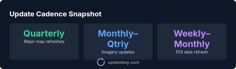
Overview of update cadences by data type
| Aspect | Cadence | Notes |
|---|---|---|
| Major map refreshes | quarterly | Varies by region and data source |
| Imagery updates | monthly–quarterly | Dependent on satellite tasking and licensing |
| POI/local data refresh | weekly–monthly | Includes user-contributed updates |
| Localization data updates | biweekly | Tied to regional update windows |
Frequently Asked Questions
How often does Google Maps refresh major data?
Major map refreshes typically occur on a quarterly cycle in many regions, but cadence varies by data source and geography. Always check regional release notes and licensing terms for specifics.
Major map refreshes usually happen quarterly, but it depends on your region and data sources.
Is there a cost to updates for Maps data?
Google Maps data pricing is generally tied to API usage and licensing rather than per-update fees. Costs depend on data access, quotas, and your agreement with data providers.
There isn’t a fixed update charge; pricing relates to API usage and licensing.
Do all regions update on the same cadence?
No. Cadence varies widely by region due to data partnerships, regulatory considerations, and data source availability. Expect faster updates in data-rich markets and slower cycles in others.
No—region by region cadence varies.
How can developers access update data?
Updates are delivered through Maps APIs and data feeds under licensing terms. Review your plan for data feeds, quotas, and update schedules to align with your product roadmap.
Access is via APIs/data feeds under licensing terms.
What affects imagery update timing?
Imagery timing hinges on satellite tasking, weather, processing time, and licensing. Urban areas may see faster imagery refreshes than rural zones.
Imagery timing depends on satellites and processing.
Where can I find official cadence guidance?
Official cadence guidance is published in regional release notes and Google’s data-licensing documentation. Exact timing varies by region and data type.
Check official release notes for cadence guidance.
“The update cadence for Google Maps is data-driven and varies by region and data source. Teams should plan around recurring refresh windows and maintain a flexible release calendar to preserve map accuracy.”
What to Remember
- Plan around quarterly major refreshes for maps data
- Imagery updates tend to be more frequent in high-change regions
- Regional cadence varies widely; verify local update windows
- Licensing and data-source rules drive update timing
- Prepare for staggered release cycles across data layers