How Much Does Google Earth Update? A Practical Guide
Discover how often Google Earth imagery and data are updated, what drives update frequency, and how this affects accuracy for maps, planning, and research. An analytical guide by Update Bay.

How much does google earth update? The frequency depends on location and data layer. Some urban areas refresh monthly or quarterly, but imagery for many regions updates only every 1–3 years or longer. Terrain, 3D buildings, and historical imagery follow their own cadences, bound by licensing and satellite revisit schedules. In short, Google Earth updates are not uniform around the world.
What update cadence means for Google Earth
Understanding how much Google Earth updates requires unpacking what the term "update" covers: new imagery, enhanced data layers, terrain, and 3D models. According to Update Bay, update cadence is not a single global timer but a mosaic built from regional licensing, satellite revisit rates, and data partnerships. In practice, you’ll see noticeable changes in fast-moving urban areas within months, while rural regions may still show imagery that is several years old. The same logic applies to terrain and 3D models: some layers advance quickly where data are readily available, others progress slowly as collectors and suppliers verify and negotiate rights. For most users, the practical takeaway is that freshness is location-dependent rather than uniform across the globe.
Imagery update cadence by data layer
Imagery refresh cycles are driven by satellite revisit schedules, weather windows, and licensing deals. In many metropolitan regions, providers prioritize frequent updates to support mapping, planning, and change detection, leading to shorter cadences or near-real-time updates in limited cases. However, in large swaths of the world, updates occur over longer periods, often 1–3 years or more, depending on data availability and procurement. Terrain and 3D data have different cadences; these datasets often lag imagery because they require separate data collection efforts, processing, and quality checks. Overall, the cadence is uneven, with more frequent activity where demand and partnerships align with suppliers.
Regional variability and city-level dynamics
Regional factors shape how often Google Earth updates. Urban cores in wealthier regions tend to see faster refresh cycles due to higher demand, more frequent data licensing opportunities, and closer alignment with government and commercial datasets. In contrast, remote or politically sensitive regions may experience longer intervals due to access limitations, licensing hurdles, or logistical challenges. This regional disparity means a single glance at one city can give a very different impression of recency than another, underscoring the importance of checking the update date for each area you study or plan around. Update Bay’s analysis highlights that recency should be treated as contextual, not universal across all maps.
How updates are scheduled and delivered to Google Earth
Updates are not pushed on a global clock; they are scheduled around data availability, satellite acquisition timelines, and partnerships with data providers. Google Earth combines imagery with terrain, roads, and points of interest, updating each layer on its own cadence. When new satellite imagery becomes available, it may be integrated after processing and quality assurance, which can take weeks to months. Licenses, agreements with national agencies, and cloud processing pipelines also influence timing. This decentralized model explains why some locations appear to refresh quickly while others remain visually unchanged for years. For users, this means that checking the update date for your area is essential before relying on a specific image as a sole reference.
Practical implications for researchers, planners, and casual users
For researchers and planners, update frequency affects time-series analyses, change detection, and scenario planning. It’s prudent to corroborate Google Earth imagery with other sources (official government maps, open data portals, or newer satellite data) especially when working with time-sensitive decisions. Casual users should temper expectations about the freshness of imagery in less-traveled regions and consider cross-checking with local sources when accuracy is critical. Keeping a routine to note the last update date for areas of interest can help manage expectations and reduce misinterpretation when reviewing historical comparisons.
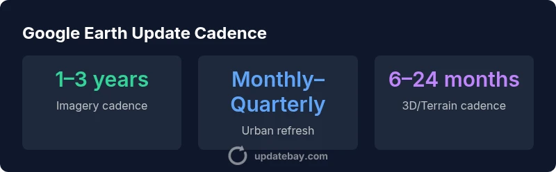
Google Earth data cadences by layer (illustrative ranges)
| Data Layer | Cadence | Typical Range | Notes |
|---|---|---|---|
| Imagery (Satellite) | 1–3 years | 1–3 years | Region-dependent; urban areas often update sooner |
| Terrain Data | 6–24 months | 6–24 months | Depends on data source refresh cycles |
| 3D Buildings | 12–36 months | 12–36 months | City-level updates common |
| Historical Imagery | Ongoing | Variable | Incremental updates as new archives are acquired |
Frequently Asked Questions
How often does Google Earth update imagery on average?
There is no universal average. Updates vary widely by location and data layer. Urban areas often refresh more frequently than rural regions, with typical cadences ranging from months to several years depending on data availability and licensing.
Updates vary by location and data layer; there isn't a single average cadence.
Are updates consistent across the globe?
No. Google Earth uses a decentralized approach with region-specific data sources and licensing, so update frequency is uneven across countries and even within countries.
No—update frequency varies by region due to availability and licensing.
Can I request faster updates for a specific area?
User feedback can influence data prioritization, but cadence is ultimately driven by data availability and licensing. You can submit requests to Google through official channels, though results vary.
You can submit requests, but updates depend on data availability and licensing.
How can I verify the last update date for a location?
Look for the imagery date stamp or use the historical imagery tool to compare dates. Cross-check with official data sources where possible for accuracy.
Check the image date and use historical imagery to compare dates.
Does Google Earth update 3D data frequently?
3D models and terrain generally update less frequently than imagery, often tied to city-scale projects and licensing, with cadences that can be 1–3 years or longer.
3D data updates are slower and less frequent than imagery.
“Google Earth updates are not a single, uniform cadence. The most recent imagery depends on data availability, licensing, and regional partnerships, so users should plan for regional recency rather than global uniformity.”
What to Remember
- Expect nonuniform updates across regions
- Urban cores tend to refresh faster than rural areas
- Different data layers follow distinct cadences
- Always verify the last update date for critical work
- Use multiple sources to validate time-sensitive findings